Lewis & Clark National Historic Trail
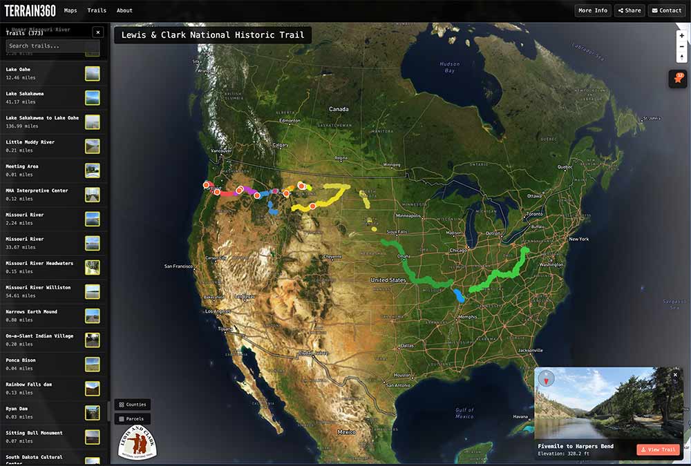
The existing NPS-partnered L&C NHT map. The Katy Trail demonstration extends this corridor onto the parallel land route Lewis and Clark traveled.
Confirmed · Rocheport Segment · Early July 2026
A 30-Mile Demonstration on America's Longest Rail-Trail
Terrain360 has already captured the entire Missouri River — Sioux City to the Confluence — as part of the Lewis & Clark NHT. This July we add the parallel land corridor: 30 miles through Rocheport — the tunnel and the Missouri River bluffs — in 360°, fully funded, free for the public, and ready to seed a full 240-mile deployment.
The Project
The Lewis & Clark National Historic Trail has been a multi-year focus for Terrain360 in partnership with the National Park Service. We have already captured the entire Missouri River from Sioux City to the Confluence — the same waterway the Corps of Discovery rowed up in 1804 and back down in 1806. Browse the live L&C NHT map.
The Katy Trail State Park runs parallel to the Missouri for the great majority of its 240-mile length. Pairing the river corridor (already complete) with the land corridor (30-mile demonstration this June, full 240 miles to follow) creates something neither can do alone: a single seamless exploration tool that lets stewards, visitors, and partners move between water and trail in one experience.
The 30-mile demo is fully funded by Terrain360. No cost to DNR, NPS, or any partner — the deliverable speaks for itself, and seeds the conversation about completing the full corridor.
An independent study of five LECL sites found $14.5M in annual visitor expenditures and 195 jobs supported. Lewis & Clark State Park alone supported 106 jobs and $12M in economic output.
The Katy pilot scales that proven model along a 240-mile recreational corridor.
The Corridor
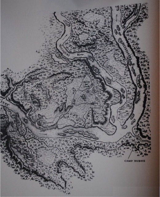
In May 1804 the Corps of Discovery left St. Charles and rowed up the Missouri. The river cut through what would become the Katy Trail’s central corridor — Hermann, Jefferson City, Boonville, Arrow Rock — long before any of those towns existed. Lewis and Clark named landmarks, mapped tributaries, and met with the Otoe, Missouri, and Osage along this very stretch. They returned the same way in September 1806.
Eighty years later the Missouri-Kansas-Texas Railroad — the Katy — laid track along the river’s south bank. By the late 20th century the line was abandoned and converted, beginning in 1986, into one of the longest rail-to-trail conversions in the country. Today the Katy Trail State Park draws hundreds of thousands of visitors a year. What it lacks is the same kind of mile-by-mile virtual access that exists for the Lewis and Clark National Historic Trail elsewhere. This project closes that gap.
Lewis and Clark depart St. Charles, traveling up the Missouri along what is now the Katy corridor.
The expedition retraces the river back to St. Louis.
The Missouri-Kansas-Texas Railroad runs line beneath the river bluffs.
Missouri State Parks begins converting the abandoned MKT bed into the Katy Trail.
The 30-mile Rocheport demonstration capture launches; pairs with the already-complete Missouri River map.
The segment is set. With the Trail's stewards weighing in, Rocheport is the confirmed stretch for the demonstration — the most recognizable mile on the Katy. Here's what's in it:
$75,000 maps the entire 240-mile corridor end-to-end. That includes the 360° capture, the custom interactive Mapbox map, a town profile for every trail-town along the corridor, the standalone Katy Trail 360 site, and the backend that lets each town keep its own content current. Thirty miles are donated as community match.
If you represent a foundation, agency, or trail-town stakeholder who could underwrite the full corridor — or part of it — let’s start the conversation. Work begins on day one across the entire corridor as soon as funding lands.
Or email jim@lewisandclarktrust.org directly to start a corridor-funding conversation.
Public projects in the same format we'll deliver for the Katy. Pairs seamlessly with the existing Lewis & Clark NHT map. Click any to explore.
The existing NPS-partnered L&C NHT map. The Katy Trail demonstration extends this corridor onto the parallel land route Lewis and Clark traveled.
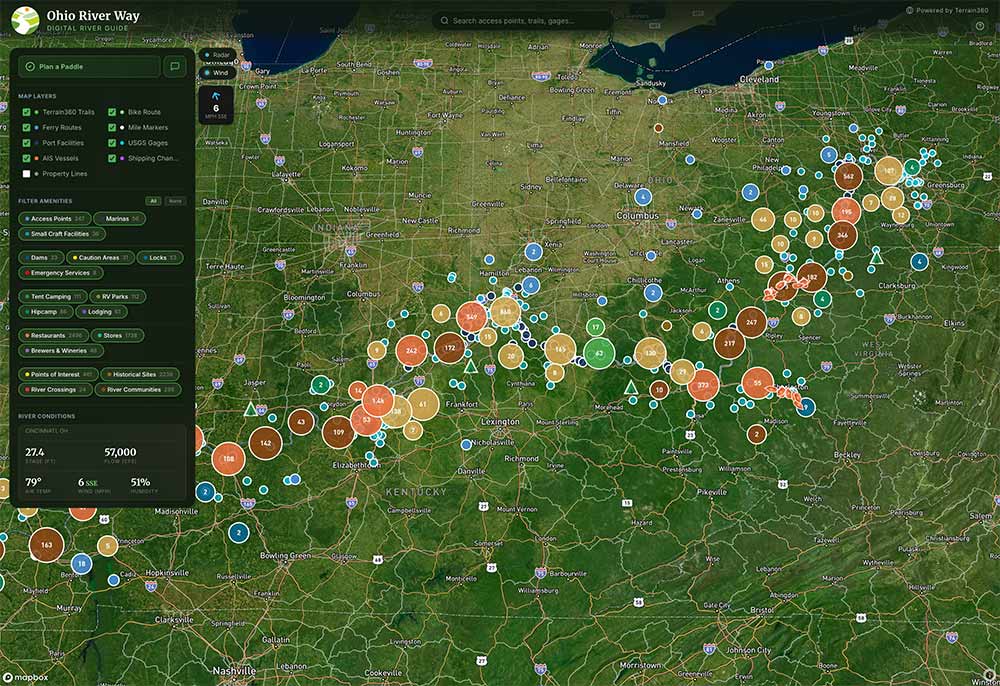
Lower Ohio River exploration tool — full GPS-tagged 360° imagery, conditions, and access points along an L&C corridor.
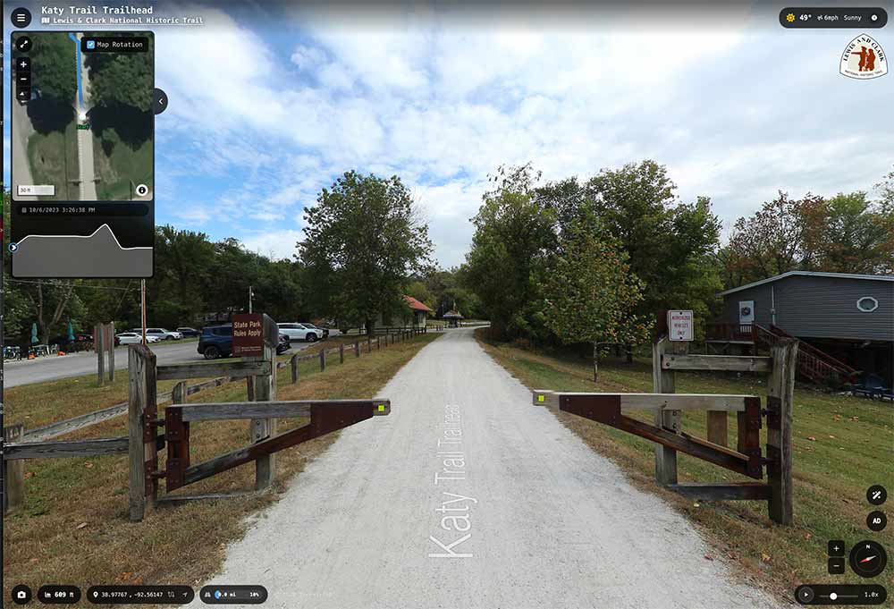
A live frame from Terrain360's Katy Trail capture — a Lewis & Clark NHT trailhead in 360°. Click to explore the viewer the demonstration will deliver at scale.

Multi-state historic trail in 360° — precedent for NHT-scale partnership work with the National Park Service.
A Natural Extension of the Project
The Katy Trail’s natural counterpart is the Rock Island Trail State Park — Missouri’s 93rd state park, designated in 2023 on a corridor donated to Missouri State Parks by Ameren in 2021.
47.5 miles of Rock Island are open today, running from Pleasant Hill to Windsor, where the corridor meets the Katy. An additional ~144 miles from Windsor to Beaufort is being developed by Missouri State Parks, with active 2026 work in Owensville and Versailles.
When complete, Rock Island and the Katy together form a continuous ~450-mile loop — the longest connected rail-trail loop in the United States. We expect to capture the open 47.5 miles in 360° and add new sections as Missouri State Parks completes them. Same equipment, same methodology, same free-public-access posture as the Katy demonstration — a natural extension once the Katy work is in motion.
Are you with DNR, NPS, Magnificent Missouri, a friends-of-the-trail group, a chamber, or a trail business? Drop your details and we'll be in touch about segment selection, introductions, and how the demonstration can complement your work.
Early July 2026 is our capture window — chosen for the full leaf-on canopy that defines the Katy in summer, longer daylight hours, and stable trail conditions after spring rain. The 30-mile Rocheport segment is fully funded by Terrain360 — no cost to DNR, NPS, the Trust, Magnificent Missouri, or any partner.
Capture is performed on a single continuous push: a calibrated 360° rig with synchronized GPS, recording every meter of trail at roughly walking pace. Most segments take 2–3 days in the field. Post-processing — image stitching, GPS alignment, blurring of any incidental faces or plates, and tile generation — runs another 2–4 weeks. Public imagery goes live on terrain360.com shortly after, alongside the existing Missouri River and L&C NHT maps.
The choice came from the people who steward the Trail. Three lenses shaped it, in this order: (1) what the trail’s stewards prioritized — DNR, Missouri State Parks, Magnificent Missouri, friends groups; (2) heritage value tied to the Lewis & Clark return-route corridor; and (3) visitor demand and trip-planning utility for first-time riders, hikers, and accessibility users.
Rocheport leads on all three. It carries the only tunnel on the Katy and the Missouri River bluffs where Lewis and Clark recorded the pictographs on June 7, 1804 — the trail’s signature mile, and a natural pairing with the river map we’ve already completed.
This is a first segment, not the last. Future blocks remain on the table for a phased full-corridor deployment — McKittrick to Hermann’s wine corridor, the Ted & Pat Jones Welcome Center at Treloar, Defiance / Augusta wine country, and the St. Charles terminus.
The 30-mile demonstration is intended to seed the conversation about a full-corridor deployment. We expect the path forward to be collaborative and phased — Missouri DNR / State Parks line items, federal grants tied to the Lewis & Clark NHT, philanthropic match through the Lewis & Clark Trust, regional tourism funding, and corporate sponsorship are all live possibilities. We’ve structured the work so that every additional 30-mile block is independently fundable — partners don’t have to commit to the whole 240 to move forward.
Capture cadence at full deployment is roughly 30–50 miles per week of field time, weather permitting, plus post-processing. A complete 240-mile Katy corridor would publish in stages over one season once funded.
Free, permanent public access at terrain360.com, alongside the existing Missouri River and Lewis & Clark National Historic Trail maps. No paywall, no app — anything a visitor needs runs in the browser.
For partners we provide:
Terrain360’s posture on this corridor is the same as on the L&C NHT: captured once, free to the public, forever.
Ryan Abrahamsen — Terrain360 founder and the person doing the field capture work — ryan@terrain360.com or 804.677.1456. The fastest path is the partnership form on this page; it routes directly to Ryan and to the Lewis & Clark Trust.
Good fits for a conversation: DNR / Missouri State Parks staff, NPS L&C NHT, Magnificent Missouri, Katy Trail friends groups and chambers of commerce, trail-side businesses, accessibility advocates, and anyone working on the Rock Island corridor. We’re also open to introductions through the Trust — Jim Mallory, Executive Director, can flag partner conversations into the right channel.
The Katy parallels the Missouri River for most of its 240 miles — the same corridor Lewis and Clark traveled in 1804 and 1806. Terrain360 has already captured the Missouri end-to-end (Sioux City to the Confluence) as part of our NPS partnership on the Lewis & Clark NHT. Pairing river and trail in one experience unlocks use cases neither side does alone:
No other National Historic Trail has anything like this. The Katy demonstration is the first step toward making the L&C corridor — water and land, end-to-end — the most thoroughly documented historic trail in the country.