Lewis & Clark National Historic Trail
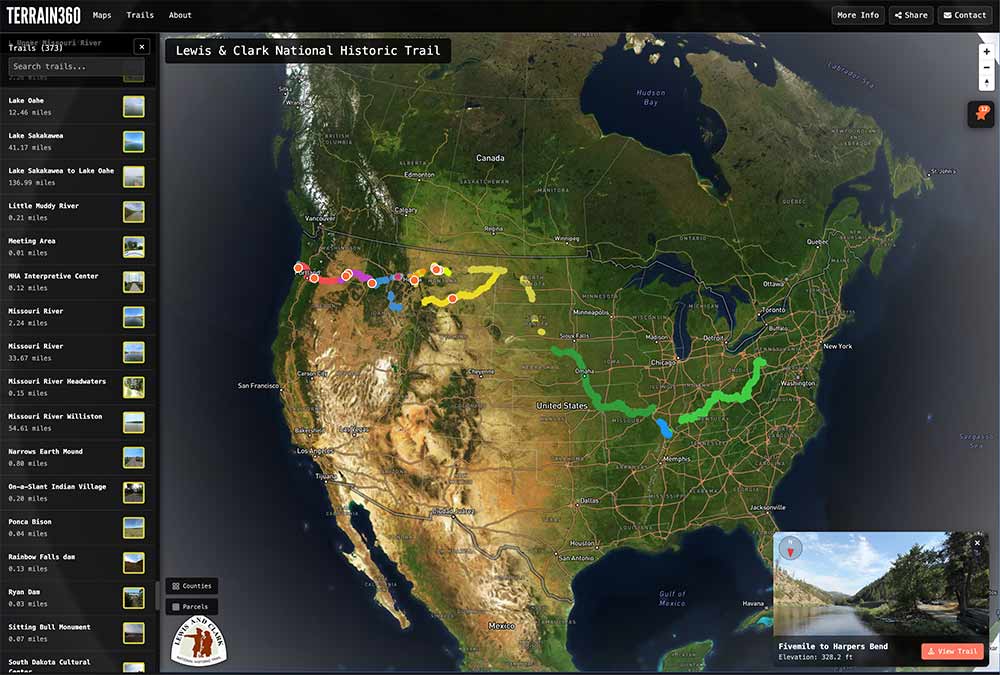
The existing NPS-partnered L&C NHT map. The Mississippi 360° campaign extends this map seamlessly into the Lower Mississippi for the first time.
Match Challenge — Deadline May 15, 2026
Mississippi River 360° Virtual Documentation — Paducah to Memphis
A Lewis and Clark Trust initiative to document 295 river miles of the Lower Ohio and Mississippi corridor — every public access site, every key landmark — and make it free to the public.
The Story
Most people know about the 1804–1806 Corps of Discovery. Far fewer know that in 1809, Meriwether Lewis traveled from the Ohio River at Paducah down to Fort Pickering — present-day Memphis — on his final journey east. That stretch of river has never been comprehensively documented. Until now.
The Lewis and Clark Trust is leading a 360° documentation effort covering every mile from Paducah, KY to south of Memphis, TN — extending the existing Lewis and Clark National Historic Trail digital map seamlessly into the Lower Mississippi.
An independent study commissioned by NPS and the Lewis and Clark Trust documented $14.5M in annual visitor expenditures across just five LECL sites — supporting 195 jobs and $7.49M in labor income.
A connected virtual Mississippi corridor extends that reach to communities along the river that aren’t yet on the map.
Lewis in 1809
Three years after the triumphant return of the Corps of Discovery, Meriwether Lewis was Governor of Upper Louisiana and under intense political pressure. In late summer 1809 he set out from St. Louis bound for Washington, D.C. to defend his administration of the territory and to publish the journals of the expedition. The chosen route ran down the Mississippi to the Chickasaw Bluffs, where Fort Pickering — modern-day Memphis — stood as the last federal outpost before the journey turned overland through the Natchez Trace.
Lewis arrived at Fort Pickering on September 15, 1809, exhausted and ill. He stayed two weeks under the care of Captain Gilbert C. Russell, recovering enough to continue. He set out again at the start of October, accompanied by his servant John Pernier, the Chickasaw agent James Neelly, and Neelly’s slave. The party crossed the Tennessee River and entered the Trace.
On the night of October 11, 1809, at Grinder’s Stand in middle Tennessee, Lewis died. The circumstances remain debated to this day — most scholars accept suicide; a vocal minority continue to argue murder. What is undisputed is that Lewis’s last great river journey followed the Lower Mississippi, and that no comprehensive visual record of that route exists.
This campaign closes that gap. Following the same corridor Lewis traveled in 1809, the Trust will document every mile from Paducah down past Memphis, building a free public archive that extends the Lewis and Clark National Historic Trail digital map into the Lower Mississippi for the first time.
Lewis sets out down the Mississippi bound for Washington, D.C.
Reaches the Chickasaw Bluffs (present-day Memphis).
Departs Fort Pickering with James Neelly and John Pernier.
Lewis dies in a roadhouse on the Trace; circumstances debated to this day.
The match is for individual donors. The full Lower Ohio + Mississippi documentation is a larger lift — and we’re looking for one or two lead sponsors to underwrite it at scale.
The Trust’s $15,000 commitment kicks the work off; matching it before May 15 doubles that. But fully documenting the 295-mile corridor — Paducah down through the Ohio–Mississippi confluence at Cairo to south of Memphis — at the depth modeled by paddletheohio.com is a foundation, family-office, or agency-scale partnership. Mission alignment with rivers, recreation, environmental science, or the Lewis & Clark legacy gets you in the door.
If a leadership commitment is on the table, let’s talk. Field work this summer; the corridor live by year’s end.
Or email jim@lewisandclarktrust.org directly to start a corridor-funding conversation.
Public projects in this same format. The Mississippi will pair seamlessly with the existing Lewis & Clark NHT map and these companion projects.
The existing NPS-partnered L&C NHT map. The Mississippi 360° campaign extends this map seamlessly into the Lower Mississippi for the first time.

The full Ohio River captured in 360°, with mile-by-mile imagery, gauge data, and access points along the entire L&C corridor. The Mississippi work begins where this map ends, at the Cairo confluence.
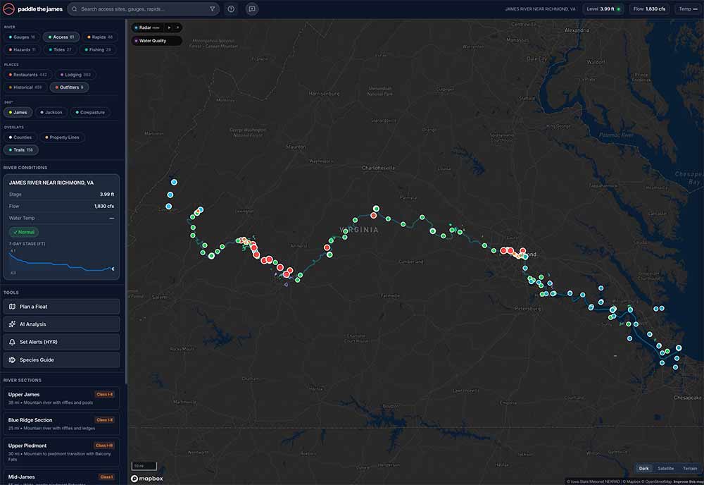
Full-river 360° exploration tool with conditions, access points, and mile-by-mile imagery — a template for what the Mississippi will become.

Multi-state historic trail in 360° — precedent for NHT-scale partnership work with the National Park Service.
The Trust has put $15,000 on the line. Match it before May 15 and every dollar you give is doubled.
Make checks payable to Lewis and Clark Trust Inc..
Lewis & Clark Trust Inc.Pledge your match below. We'll follow up with mailing instructions or accept a letter of commitment by email.
Every dollar above the $15,000 match supports Phase 2 — the Katy Trail 360° demonstration in late June 2026.
Yes. Lewis and Clark Trust, Inc. is a registered 501(c)(3) nonprofit — EIN 45-4290831. Every dollar you give is tax-deductible to the fullest extent allowed by law, and you’ll receive an acknowledgment letter for your records.
Donations made through this page are restricted to the Mississippi River 360° corridor work — they fund field capture, post-processing, public hosting, and partner integration on the Lower Ohio and Lower Mississippi. The Trust files an annual Form 990; financials are available on request.
Every dollar you give still goes directly to the project. The match is a stretch goal, not a contingency — the work is moving regardless.
If we fall short of the full match by the deadline, the Trust’s board has discretion to (a) extend the campaign with a revised target, (b) reallocate the matched portion to the closest-aligned project on the Lewis & Clark return route, or (c) carry remaining matched funds forward to the next phase of capture. Donors are notified of any reallocation decision and can request that their gift follow the same path or be applied elsewhere.
Yes — and we actively want partners on this corridor. Good fits include:
Partnership can take the shape of in-kind support (river access, lodging during capture), advisory input on heritage and access points, content collaboration, or co-branded distribution. Reach out to jim@lewisandclarktrust.org or ryan@terrain360.com — a 15-minute call is the fastest way to see if there’s a fit.
Free, permanent public access at terrain360.com, alongside the existing Lewis & Clark NHT and Ohio River maps. No paywall, no app — anything a visitor needs runs in the browser.
For partners we provide:
Terrain360’s posture on this corridor matches our stance on the L&C NHT: captured once, free to the public, forever.
This is a partnership between two organizations:
The two organizations have collaborated on Lewis & Clark corridor projects since 2024. The Mississippi River 360° campaign extends that working relationship onto Lewis’s 1809 return-route corridor — Paducah to south of Memphis — for the first time. Reach Jim at jim@lewisandclarktrust.org or Ryan at ryan@terrain360.com · 804.677.1456.